Open source item tracking for all geocaching platforms

Open source item tracking for all geocaching platforms
GeoKrety (From Greek geo = ‘earth’, and Polish krety = ‘moles’) is a service similar to TravelBug(TM) or GeoLutins, aiming at tracking objects you leave in geocache containers. People move these registered objects (called GeoKrety) from cache to cache and register each move with this service. The trip of each GeoKret is then presented on a map.
GeoKrety are not a trade item, you do not have to put something in the cache to take a GeoKret, and you should not take something from a cache in trade for a GeoKret. If you should take something from a cache, you should make a trade, and you can place the GeoKret.
The service is absolutely free (contrary to TravelBug) and easy to use. A GeoKret can be anything, but in most cases it is a small puppet.
Please see (and edit, if necessary) the article about GeoKrety at Wikipedia.

How to pronounce GeoKrety? ;)
Then you have to:
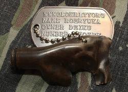
Examples of ready GeoKrety
Watch an instructional screencast about registering and making your own GeoKrety.
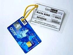
A small puppet with a tag
When you want to track books, CDs, DVDs dropped to cache containers. Just stick a GeoKret number and a short instructions on the back side of a cover.
When you want to track yourself and write something like GeoBlog
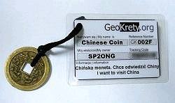
Regular GeoKret but in form of a coin
Regular GeoKret but in form of a postcard/mail. Check rules below.
| Icon | Description |
|---|---|
 or
or

|
I've dropped a GeoKret when you've left a GeoKret in a cache. |
 or
or

|
I've grabbed a GeoKret when you've taken a GeoKret from a cache and are not going to put it to another cache soon. |
 or
or

|
I've met a GeoKret when you've met a GeoKret in a cache but haven't taken it with you. |
 or
or

|
I've dipped a GeoKret when you take a GeoKret for a cache-tour; this is the same as doing a drop and then grab - the visited location is logged but GeoKret is still in your inventory. |

|
Comment when you want to write a comment :) |

|
Hibernation / archiving when a GeoKret has been missing for a long time. |
You can easily indicate the location of GeoKrety by entering either the waypoint or the name of cache.
| Icon | Type | Url | Comments |
|---|---|---|---|
| OP | OpenCaching | Polish database | |
| OC | OpenCaching | German database | |
| OK | OpenCaching | UK database | |
| OS | OpenCaching | SE/NO database | |
| OB | OpenCaching | NL database | |
| OZ | OpenCaching | Czech database | updated manually from time to time |
| GA | GeoCaching Australia | updated daily (lat, lon, cache name, link) | |
| TR/VI/MS/EX | GeoCaching Russia | updated every two hours (lat, lon, cache name, link, owner) | |
| GE | gpsgames.org database | updated daily (lat, lon, cache name, link) | |
| GD | gpsgames.org GeoDashing | waypoints (updated monthly) | |
| unique name | geopeitus.ee | Estonian database | updated daily (lat, lon, cache name, link) |
| GR | Geocaching Romania | romanian database | updated manually |
| GC | Geocaching Hungary | hungarian database | updated daily |
| WPG | WaypointGame | Polish Waypoint Game | for generating map -- updated daily |
![]()
![]()
![]()
![]()
![]()
![]()

From waypoints listed below we can generate a proper link to the cache:
| Icon | Type | Url | Comments |
|---|---|---|---|
| GC | Geocaching | geocaching.com | |
| N | Navicache | Navicache.com |
But maybe in the future we will be able to do more. So enter the waypoint anyway.
GC waypoints are not fully supported by GeoKrety (Licensee shall not remarket, resell, and/or redistribute the Data or any derived portion(s) of the Data in its digital form to any third party whatsoever… from waypoint license agreement ). However you can easily use GeoKrety with GC caches.
There are two options:
This is a greasemonkey script (written and maintained by simor).
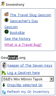
You also need an account on geokrety.org. After installing GKT in your browser, you will see an extra [ GeoKrety.org ] panel on the right hand side of every GC cache page. From the list of GeoKrety pick the one you wish to drop and click "Drop selected GK" - you will be redirected to the standard logging page with both the GC Code and coordinates already filled in. Check the date, add a comment and you're done.
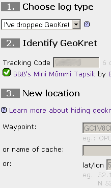
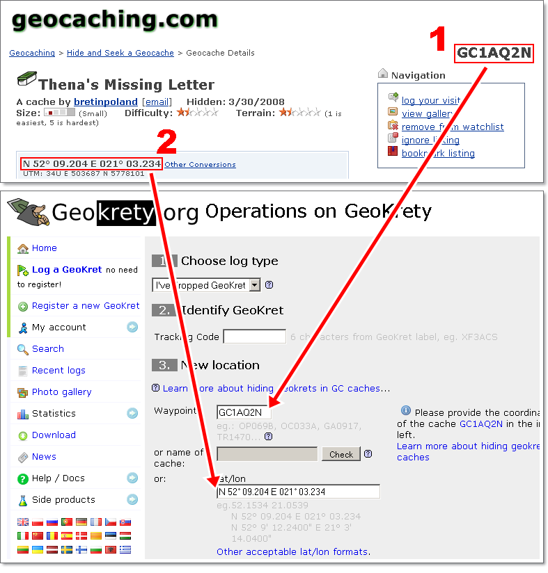
Go to Log a GeoKret page and under the section New location enter the following:
Here is an example:
Note: according to groundspeak,
geocaching.com users may use and log geokrety ;)
I have checked with Brian, and his definitive answer is that
these 'rogue' TBs are not of concern to us - reviewers and
GS staff. We cannot govern their usage, and Geocachers are
allowed to give out GC codes.
You can enter lat/lon coordinates in different formats:
52.205205 21.190891
52.205205/21.190891
N 52.205205 E 21.190891
+52.205205 -21.190891
52 12.3123 -21 11.45345
N52 12.3123 W21 11.45345
+52 12.3123 -21 11.45345
N 52° 10.369' W 021° 01.542'
52 12 18.74 -21 11 27.21
N52° 12' 18.74", W21° 11' 27.21"
52° 12' 18.74", -21° 11' 27.21"
| Icon | Action | Description |
|---|---|---|
| edit | an email address, description, log entry | |
| delete | a log entry, photo or comment | |
| upload photo | attach a photo to a log entry or your profile | |
| known GeoKret | you already logged this GeoKret before, now you can log it without its Tracking Code (it is provided for you automatically) | |
| avatar | move mouse over this icon to see GeoKret's avatar | |
| comment | you may comment a log entry or a news post | |
| report missing | you may report a GeoKret missing if you have visited the cache where the GeoKret should be but it wasn't there |
It is a public number that may be used to refer a GeoKret. It consists of 'GK' prefix and 4 digits in hexadecimal system. You can use it to search a specific GeoKret or to link to this GeoKret. It is visible to everyone.
It is a secret identification code which is required to post logs such as "Grab", "Drop" and others for a GeoKret. Only the owner and geocachers who found the GeoKret should know this code. It is not recommended to post it anywhere. Of course this code must be written on GeoKret's tag to allow finders to log it.
For easy logging dropping or grabbing during your trip, I've added the possibility of attaching QR code on the GK label. QR Code is a kind of bar code, which can be "scanned" by your mobile phone, which will redirect you to the proper page at geokrety.org ; you will not have to enter the Tracking Code, everything will be encrypted in the QR. Read more about QR Code.

The QR code with encrypted address of geokrety.org page.
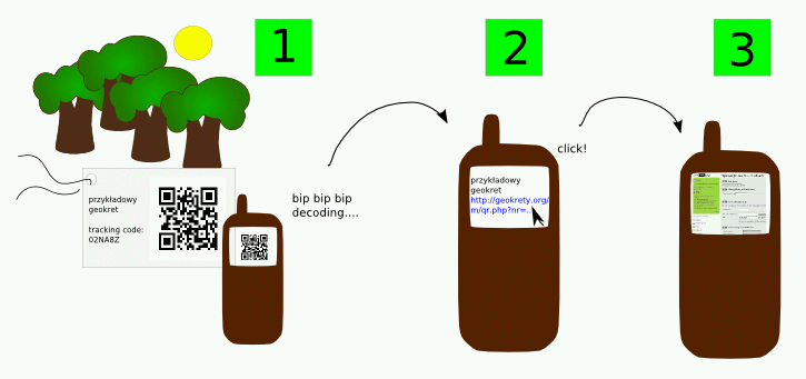
You can use the free software for your mobile phone, eg: Barcode Scanner
There are others trackable items systems:
Your e-mail address will be not transferred to third parties. Your password is one-way encrypted, so it can not be revealed.
We use cookies only to ensure you can correctly navigate our website. This cookie will stay on your computer for:
It's absolutely harmless. That's it! 😀
Cookies is automatically destroyed when you explicitly logout. However, if you would like to, you can change your cookie settings at any time in your browser.
The connection to our server is secured using TLS encryption. You should see a green lock in your navigator address bar. It indicate that the communication between you and the server cannot be read by anyone else and it's fine for your credentials!
Our server is using IPv6, meaning we are ready for the future! IPv6: The Future is Now More than Ever
To get more help on GeoKrety contact us or visit the forums:
| languages | platform | group name |
|---|---|---|
| Français | GeoKret en France | |
| Nederlands | GeoCaching met GeoKrety.Org | |
| Polski | Opencaching Poland | GeoKrety |
| Deutsch | geoclub.de forum | Geokrety |
| Nederlands | Opencaching Benelux | GeoKrety |
